

Ipperwash beach land is a historic trail for Kettle and Stony Point
By Colin Graf
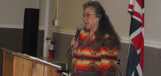
PORT FRANKS – Speaking to a hall full of angry property owners in the Ipperwash area on March 29 , the administrator of the Chippewas of Kettle and Stony Point, Lorraine George, stood up to explain why the First Nation sent backhoes and workers to dig up and remove barricades last December that had kept the Ipperwash beach along southern Lake Huron out-of-bounds to vehicles for over 40 years.
The beach land is an “historic trail”, one of two used by reserve residents to travel between the currently established First Nation at Kettle and the lands of Stony Point, 2.5 kms. away. Stony Point is the land of the former Stoney Point First Nation that the federal government expropriated in 1942 and made into Camp Ipperwash. The former camp was later occupied in the early 1990s occupied by a group calling themselves the Stoney Pointers on the land they called Aazhoodena (next town over). The boundary of Stony Point is where protestor Dudley George was killed by the OPP in a 1995 confrontation.
The group listened almost silently as George shared stories from the past explaining why her people are entitled to use the beach.
“My Dad often talked about the midwife who walked that trail to get where she was needed,” George recounted. “She was never called or asked to come, but when she showed up, everyone knew it was birthing time,” George told the crowd of over 200 non-reserve residents at the meeting sponsored by their group, the Centre Ipperwash Community Association. “I’ve heard many tales from my father about the trails. Our oral history continues up to my generation,” she said.
There will be no vehicles allowed on the beach for this summer, said Bill Weber, mayor of the local municipality Lambton Shores — a decision agreed to by both beach residents and citzens Kettle and Stony Point First Nation. The agreement was reached with help from provincial officials who have convened several meetings of the working group behind closed doors since January. The group aims to find a “common vision” between native and non-native residents, George said, and participants hope to build good relationships between the antagonists, she told the meeting.
Angry property owners started blockading the beach in front of their homes last December, as trucks paraded along the beach front after the removal of the gates. They claim their land deeds say they own the property to the water’s edge. George said the working group has confirmed that’s true, but the province has told them there is a “Crown reservation” of up to 7 m that guarantees “exclusive use and access to the public” along the beach.
Yet “over-riding all that” is the question of aboriginal title, according to George. Her chief and council are asserting aboriginal title to the lands in the area, based on a 2014 court ruling in British Columbia, but that doesn’t mean “there is any intent to claim your personal property, “ she told the wary residents. Aboriginal title means the Kettle and Stony First Nation citizens have the right to use the land in traditional ways such as hunting, fishing, and gathering traditional medicines, she said.
The community believes their title extends across much of south-western Ontario, from Walpole Island at the mouth of the St. Clair River inland beyond London, and north along Lake Huron to the Goderich area, George said.
The barriers, located at the margins of roads that reach the edge of Lake Huron, have been a “troublesome presence” to the First Nation’s people since they were erected in the early 1970s as a temporary measure after a severe storm caused damage to homes along the beach, without consulting the chief and council of the time, she told the audience. The barricades were only built to “protect people from unsafe conditions and allowed clean-up from that storm,” she said.
The shoreline residents don’t agree with George’s historical recollection. The 1972 storm “precipitated” the closure of the beach, but it had been planned for years, said long-time property owner Helen Rupke.
One stretch of property in the process of being returned to Kettle and Stony Point First Nation —the former Ipperwash Provincial Park—will become the site of a heritage and cultural centre open to the public, George explained, which will describe the history of the First Peoples of the area and display archaeological artifacts dating back 8,000 years.
While both sides have shown their “visions” of what the beach area should become, potential for conflict is still very much alive, according to resident and Lambton Shores councilor Gerry Rupke. Even though an agreement is in place for this summer, “we haven’t won the game yet,” he said in an interview following the meeting. “They (Kettle and Stony) are claiming aboriginal title to 2 million acres and the public needs to be informed about this,” he said. “I can guarantee almost everyone’s property in this room is affected. We need to let our government know this is unacceptable,” he added.
The question of driving on the beach is still a sticking point. The beachfront residents want only pedestrian traffic, while in the Kettle Point vision there “may be vehicles on the beach”, Lorraine George admitted under questioning by councilor Rupke. The Kettle Point Beach Management Strategy includes both driving on the beach and paid parking in the third year of the plan, he claimed. Despite several requests, Kettle Point officials have not made a copy of the management strategy document available to the media.
Driving on beaches is “becoming widely recognized” among scientists as damaging to grasses and small plants and can compact the sand making beaches more susceptible to erosion from wind and wave activity, according to Karen Alexander of the Lake Huron Centre for Coastal Conservation, who also spoke at the meeting.