Mapping our traditional knowledge

By Rick Garrick
Wahnapitae’s Nicole Recollet is developing an online interactive biodiversity map for citizens to post wildlife sightings in the surrounding area using GIS (geographic information system) technology.
“(They can post) if they’ve seen certain species in the area of our community or even in our watershed, so we can have an idea if … we are seeing any of those species that are at risk,” says the Robinson Huron community’s geospatial applications specialist. “That will be an advancement for our community to get more interactive with our GIS system. Even if they have a picture, they will be able to attach the picture to (the map).”
Recollet says the community is also looking at developing their own aerial images using drone camera equipment, noting the aerial imagery they obtained previously was “very costly” and limited to when it was captured.
“(It) is a very cost effective way of doing it, maybe to monitor something like our landfill site, for example,” Recollet says. “It would be a good way to see it change over time, so every six months maybe we would be able to capture this aerial photo right on top of the landfill site as well as other sites we would want to see how they change over time.”
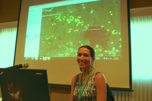
Recollet recently shared her knowledge about GIS systems at the 2015 Northern Ontario First Nations Environment Conference, where she participated in the GIS for Protecting Values Panel Discussion along with Pays Plat’s Gary Bouchard and Mushkegowuk Council’s Barb Duffin. The annual conference was held Sept. 29-Oct. 1 at the Best Western Plus Nor’Wester Hotel and Conference Centre near Thunder Bay.
“We answered some questions about how we use the geographic information systems within our First Nation communities and on many of our environmental projects as well as traditional ecological knowledge (TEK),” Recollet says. “They asked a lot of questions about what software we were using, if we would recommend the software we were using for other First Nations to use on their TEK case studies.”
Recollet says her community has used GIS for ecological land classifications, campsite monitoring and environmental monitoring processes. “We have used it in forest management,” Recollet says. “We used it in our canoe journeys that we have been doing for our traditional ecological knowledge database.” Recollet says the community also uses GIS to monitor the drainage from a 1996 spill at a nearby mine site.
“We have to (do) the water sampling to make sure the cleanup was done properly and is still not affecting our waterway,” Recollet says. “We use our GIS system to (pinpoint) the location sites of these water samples as well as all other data associated with that collection.”
Recollet says GIS was also used to map property lots, houses, buildings, septic systems and wells in the community. It is also used for land use planning to indicate areas for development and areas that should be protected, such as the sanctuary at Bass Lake.
In addition, the community has developed an Interactive Aquatic Invasive Species Map for the Anishinabek Ontario Fisheries Resource Centre. The interactive map allows First Nation communities to identify the location of aquatic invasive species in their community and to report the aquatic invasive species.
The Northern Ontario First Nations Environment Conference featured a variety of presentations, including the Being Prepared for the Weather of the Future and Goal Setting workshops on the first morning. The other workshops were split up into three areas: Values Protection; Environmental O and M; and Resource Management.


