

Dokis First Nation soars in mapping projects
By Kelly Anne Smith
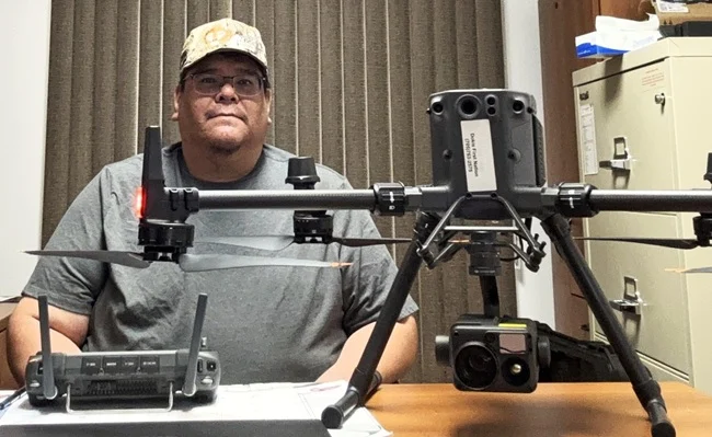
DOKIS FIRST NATION- The Dokis First Nation Lands Administrator always looks forward to going to work. Randy Restoule of Dokis First Nation obtains data from new heights using drones and then preserves the Nation’s data.
Through the use of the technology, Dokis First Nation is more efficient and self-sufficient, says Restoule.
“By having access to this new technology and with the accuracy of the equipment that we use now, it resolves issues in a more efficient manner as opposed to having a surveyor come into the community. It makes things more efficient in the administration and for the members as well.”
Restoule says road conditions in the spring can be pretty treacherous for Dokis First Nation. The Nation can do the work internally and not rely on outside surveyors.
“Most people avoid coming in this time of year. Delivery trucks even. Some days, the mail doesn’t come in. Accessing Dokis can be a little challenging in the winter as well. We seem to be the last road plowed in the municipality. If an issue was to occur today and we didn’t have this equipment, we might be delayed a month to get a surveyor in, especially during the winter months. Basically, all the field work shuts down. We have been out a few times during the winter to do locates or whatever.”
Using drones for land administration gives quick results as needed.
“Using the drone, we can get updated imagery as required. We don’t have to wait for Google Earth to update the areas. As soon as development is complete, we can be flying the drone and get the updated imagery and enter it into our GIS system.”
Drone use is featured in a significant project of the Lands Department in determining historic water levels since the damming of the French River. Restoule gives context.
“Canada built a series of three dams here on the French River, which controls Lake Nipissing water level into the French River. When those dams were built, the water level increased about six feet.”
Restoule explains that the department had to go through an exercise working with historical data and imagery to determine the historical level prior to those dams.
“We were able to create 3D models and get area calculations of how much land was actually lost due to flooding. In the case of the Lake Nipissing side, it was a different technology that we had to use. It’s essentially like using sonar underwater, but we hired a consultant to do that part. I’m able to fly the drone to get a model of the lower French River during the summer period when it’s at its lowest level. We’ll have a whole 3D model of our shoreline on the French River side.”
Having the precision of the drone equipment on hand benefits Dokis First Nation citizens. Restoule worked with a community member that morning to determine the location of the property line.
“I had the imagery and printed that out. And downloaded the original survey, which was conducted in ’85 and went to the roadside of the member’s property and showed him where the survey marker was and the line of the edge of his property. It wasn’t as he remembered when he was initially given that lot. I said, ‘There were no other surveys conducted and this is where the survey pin is. ‘ That doesn’t prevent the members [from] coming up to an agreement if they need to create a new survey to alter the edge of the properties.”
Restoule gave the example of Luke Street, one of the subdivisions in Dokis First Nation. When it was constructed, there wasn’t any technology available, so there was only a paper survey with no reference points on the parcels of land.
“In the new subdivision, we have an issue where almost every development on that street is partially over on their neighbour’s property. So, the implications of that, at the time maybe, or even if it’s family today, maybe there’s no issue, but you got to think 20, 30, 40 years down the road, when there’s a new land owner and they want to build, they want to expand. They think they have a lot of land around their home, but their home is partially in their neighbour’s property already. That’s when it creates conflict.”
The acquisition of a new device for field work is capable of up to one centimetre accuracy for GPS location.
“Now with this new device, I could with confidence say, ‘Your survey pin should be here, but whatever developments that happened, it’s no longer there, backfill or whatever.’ But I have confidence now to say, ‘This is where your pin should be and this is the angle of your lot wide’.”
The drone’s range is a 14-kilometre radius. Restoule has a drone pilot certification through Transport Canada, a federal institution that is responsible for transportation policies and programs. He has to keep the drone in his line of sight.
“Night operations is a little different. And of course, if it’s a time of emergency, if it’s a search and rescue, I’m not going to be worried about keeping the drone in line of sight. I’m more worried about finding the individual. We have a special infrared camera for that purpose. It has night vision capability.”
The drone technology will be useful for checking the safety of ice in the winter. Restoule says that through the imagery, you can tell by the heat signature whether it is water or thick ice.
“Ideally, this coming fall, we’ll be able to take some photographs and determine where the weak ice locations are, especially on the river here.”
Restoule advises youth and others interested in geographic information systems (GIS) to pursue online certification, as he did, through Ontario’s continuing education portal.
“The technology is so common now in all of these fields, geography and environment, especially that there is some form of GIS or mapping associated within these programs. But for a specialized certification, somebody that wants to fly a drone every day, I would highly recommend a specialized GIS and orthophoto certification specializing in orthophotos.”
Restoule says he tries to find individuals to help with field work.
“It’s a great experience for them. I believe any youth that is out where they’re hunting or fishing or whatever may be on the four-wheeler, they should have a basic understanding of a GPS handheld position device just for navigation and safety.”
A stage four archaeological investigation is underway this summer, says Restoule.
“We’ll be including the students in that to map, photograph, and document the site. They won’t be able to fly the drone, again, because of that certification. To be able to experience and see how everything is processed on the computer afterwards, there’s no problem there.”
Growing up with video games, Restoule says he’s been training since he was very young.
“It’s all the same type of controls and everything. The students coming in now understand this technology very easily. It’s not much for them to grasp technology. The main thing is to show the youth the opportunities available if they were to get into that field.”
Another big project for the Dokis Lands Department will be incorporating their new ground-penetrating radar device. They are currently in the process of being trained on the newest acquisition.
“In coordination with the drone, the LiDAR mapping, and the detailed mapping of elevation, we’ll be taking photographs of our cemeteries and incorporating the ground-penetrating radar data to identify burial sites that have been forgotten or unmarked graves here in our cemeteries,” he explains. “We have equipment that is actually better than what the surveyors are using right now. But, we don’t have the recognition by the government to be able to register our own land survey. We still have to go through a federal land surveyor for that registration process. So, the long-term plan is to work with other First Nations, Wiikwemkoong, for example. They have their own agreement where they submit their own survey, which would result in more efficiency in the administration and lower costs to the members as well.”
Finally, Restoule says the new devices using technology make things exciting every day.
“I look forward to getting to the office every day. I enjoy my time being able to work out in the field. Essentially, the drone is capable of flying our whole reserve and I don’t even have to leave the office. I still prefer to be out on the land. By being there personally, you have a better connection as opposed to just a photograph. Fieldwork on site will always be required. There are certain things that a drone can’t pick up, like artifacts, or you can see finds of a settlement area.”